The Evolving Physical Geography of the UK
 "Old British Geological Map Vector" by sjrankin is licensed under CC BY-NC 2.0
![]()
![]()
![]()
Watch this for a quick introduction to the physical geography of the UK!
"Old British Geological Map Vector" by sjrankin is licensed under CC BY-NC 2.0![]()
![]()
![]()
|
First you need to download the The Evolving Physical Geography of the UK workbook.
Choose the best format for you: |
Top Study Tips!
Don't forget to regularly revise over the content from this topic. Your teacher will set you assignments on Seneca for this. If you can't find the assignment, check here for the Seneca Tasks. |
|
Need more help?
Have a look at the knowledge organiser for this topic to help condense your understanding. Use the PLC to check on how well you understand what we are learning during this topic. | ||||
|
Starter:
READ over the instructions for each task you are do complete for Lesson 1. This will help you to focus on the information you will need as you go through the independent research links, videos and tasks. Note: To show your work each lesson you could - 1) Complete the Word Document provided and upload completed work to Show My Homework or email to your teacher. 2) You can print off the pdf file, complete the tasks, take pictures or scan your work and upload to Show My Homework or email the work to your teacher. 3) If you are really stuck, you can simply complete the tasks on a sheet of paper and send your completed work to Show My Homework or email your teacher. |
Main task 1:
READ through the BBC Bitesize lesson on the UK's Physical Landscapes (pages 1-4). When you have finished, TEST your understanding by using the quiz at the end. Record your quiz score at the top of the workbook page for Lesson 1. Main task 2: Next, fill in the DEFINITIONS in the workbook based on your learning from the BBC Bitesize page. Stuck? Look on the third page of the Bitesize lesson. Main task 3: Now, look at the two maps of the UK in the workbook underneath the definitions task. Use the two maps to DESCRIBE the location of the upland areas (brown) (Use compass directions, as well as countries of the UK). Then, use the two maps to DESCRIBE the location of the lowland areas (dark green) (Use compass directions, as well as countries of the UK). Main task 4: Finally, look at the last task on the page. You are going to now illustrate your understanding of the rock types in the UK. DESCRIBE the key differences between the different rock types found in the UK. Stuck? Have a look at the picture next to where you will write your description. It includes details on Sedimentary rocks. Can you use this and your knowledge of Metamorphic and Igneous rocks to describe how they are different? |
Plenary:
Check your understanding Complete this Google Quiz all about the Physical Geography of the UK. RECORD what you achieved out of 24 points on this quiz at the bottom of the Lesson 1 workbook page. |
|
Starter:
READ the first page from the BBC Bitesize lesson on Coastal Processes. Main task 1: Based on your reading, EXPLAIN what causes a wave and then DEFINE the fetch in your workbook. Stuck? Watch this to help your understanding of how waves work. |
Main task 2:
Now use your understanding and the diagrams of constructive and destructive waves to COMPARE these two types of waves in the table provided in the work book. Stuck? Have a look at this video to go over the way waves work and how constructive and destructive waves differ. |
Plenary:
Take your learning further - either draw your own diagram of the two different wave types and ensure you label on the key differences OR make a model of the two different wave types, and use post-it notes or cut-up paper labels to show the differences. Send your teacher pictures of your diagram or model! The best ones will make the website and will be tweeted by the department! Challenge - do the above task, but try it from memory alone! How much did you manage to remember? What did you forget to include? |
|
Main task 1:
In the workbook, EXPLAIN what weathering means. Then EXPLAIN two of the types of weathering are: PHYSICAL and CHEMICAL. Challenge - what is the third type of weathering? Can you define this as well? Main task 2: Next, DRAW diagrams to illustrate three of the types of MASS MOVEMENT. Don't forget to add clear and detailed labels for your diagrams. Hint - slump is another word for rotational movement Stuck? Have a look at this video to help remind yourself of how mass movement works. |
Plenary:
Can you CREATE your own quiz for your peers or family about what you have learnt so far over the past three lessons? Make it easy - using multiple choice questions - or make it hard - fill in the blanks, short or longer mark questions. |
|
Starter:
READ the fourth, fifth and sixth pages from the BBC Bitesize lesson on Coastal Processes. Main task 1: COMPLETE the table on the worksheet under the subtitle Erosion. You are to DESCRIBE in each box the four types of erosion found at the coast. Stuck? Watch this video (up to 12.00) for support. Challenge - can you draw diagrams to go along with each description? |
Main task 2:
Do the same in the table below on the workbook to DESCRIBE the four types of transportation found at the coast. Stuck? Watch this video (up to 21.48) for support with transportation. Challenge - can you draw diagrams to go along with each description? Main task 3: DRAW an annotated diagram in the box on the workbook to EXPLAIN the process of longshore drift. Stuck? Watch this video to help. Challenge - can you explain in a paragraph how longshore drift occurs? Include this with your diagram. |
Main task 4:
EXPLAIN what the process of deposition includes and give 2 REASONS why it happens. Plenary: Use the test on BBC Bitesize to check your understanding of Coastal Processes over the past 3 lessons. RECORD your score out of 10 in at the top of the workbook pages from today's lesson. WRITE down the correct answers for any of the questions you scored incorrectly. Be sure to review this content again right away to correct your understanding. |
|
Starter:
READ page 1 on the BBC Bitesize page for Coastal Landforms. Challenge - after/during your reading, draw labelled diagrams for yourself to consolidate your understanding. This will help you build this knowledge into your long term memory! Main Task 1: WATCH this video to dig deeper into your understanding of Headlands and Bays. Next in your workbook, WRITE down the named example provided in the video and then EXPLAIN how headlands and bays form (using the diagram to help you). Remember to include key terms where necessary. |
Main task 2:
Next, WATCH this video about wave refraction. You can either take NOTES in the space on the worksheet OR you can watch and then attempt the challenge by EXPLAINING the process in your own words. Main task 3: WATCH this short video about how a wave cut platform is created. In your workbook, CREATE four annotated (labelled) diagrams to illustrate how a wave cut platform is created (Steps 1-4). Stuck? Use 4 out of the 5 steps from the Erosion page from BBC Bitesize to help decide what will go into each step. |
Main task 4:
WATCH this short video all about caves, arches, stacks and stumps. In your booklet, first NAME an example of a place in the UK where you can find these features. Next, EXPLAIN around the diagram how each process causes the next landform to be created (eg cave, to arch). The first one has been done for you (Remember to include the erosional processes!). Plenary: Take your learning further - can you make a model of how any of the three erosional landforms are created? Make your model, include labels, and take a picture to share with your teacher. The best ones will be shared on the website and our Twitter page! |
|
Starter:
READ pages 2 and 3 on the BBC Bitesize page for Coastal Landforms. Challenge - after/during your reading, draw labelled diagrams for yourself to consolidate your understanding. This will help you build this knowledge into your long term memory! Main Task 1: WATCH this video to dig deeper into your understanding of how sandy beaches are formed - only watch to 3.30. FILL in the detail in your workbook when you have finished watching the video about sandy beaches. WATCH this video to dig deeper into your understanding of how pebble beaches are formed. FILL in the detail in your workbook when you have finished watching the video about pebbly beaches. |
Main task 2:
WATCH this video about sand dune formation. Use this to FILL in the 4 steps on your workbook. Next, WATCH this video all about spits and bars. Use your understanding to draw annotated diagrams (as step by step processes) to EXPLAIN the formation of spits and bars. Main task 3: Attempt this Google Quiz on for Coastal Processes and Coastal Landforms. Record on your booklet your score. |
Plenary:
Take your learning further - can you make a model of how any of the four depositional landforms are created? Make your model, include labels, and take a picture to share with your teacher. The best ones will be shared on the website and our Twitter page! |
|
Starter:
READ pages 1-3 on the BBC Bitesize page for Human Activities on Coastal Management. Challenge: As you read, start to THINK about how you would rank these different management techniques. Would you judge according to cost? Beauty? Sustainability? Write down your initial thoughts on a sheet of paper and see if you change your mind after the lesson. |
Main task 1:
First, DEFINE what hard engineering, soft engineering, and managed retreat mean. Stuck? Watch this video to review. Main task 2: Use your knowledge to COMPLETE the tables explaining how each named method in the workbook works and its advantages and disadvantages. Stuck? Use the Knowledge Organiser at the top of the page for some ideas. Challenge: Now rank each method according to how effective you think it is - remember before when you were asked to consider how you would judge the methods? EXPLAIN what criteria you have used to judge the different techniques. |
Plenary:
Tweet it or Instagram it! CREATE a 30 word tweet or a quick picture to SUMMARISE what you have learnt today! |
|
Starter:
READ this brilliant summary of the Lyme Regis case study from the British Geographer! Challenge: Watch this amazing short documentary by students from Lyme Regis that covers the issues around coastal management in the town. Use this to extend your understanding. |
Main task 1:
In your booklet, EXPLAIN why Lyme Regis needs protecting and LIST the 4 specific strategies that have been used to protect this coastline. Main task 2: Now, consider what positive impacts and negative impacts the coastal management in this location have created. WRITE your ideas in the boxes provided. Stuck? Have a look at this help sheet to prompt your ideas. Main task 3: In the blank space in your workbook, answer the following exam style question based on what you have learnt in today's lesson - 'Explain why there may be conflicting views on the methods of coastal management.' 4 marks |
Plenary:
3, 2, 1 - Lift-off! Give me 3 key terms you needed to use in today's lesson. Give me 2 facts you didn't know about before. Give me 1 sentence to summarise today's lesson. Challenge: complete this Google Quiz to illustrate your knowledge of Coastal Management! |
|
Starter:
READ this page all about the features of a river basin. Use what you have learnt to ANNOTATE the definitions onto the features of a river image in your workbook. Stuck? WATCH this short video to cover the key words of the drainage basin. Challenge: Can you add extended annotations based on the water cycle's influence on the river basin? (OR) Can you create a model to illustrate your knowledge? |
Main task 1:
WATCH this video about a river's profile. Use the detail to help FILL in your workbook details about the long profile and the cross profile of a river. When you have finished describing these, you will need to fill in the table about the Upper, Middle and Lower Courses, DESCRIBING what happens to the width and depth of the river channel as the river changes in each course. Stuck? READ over this website to check your understanding of a river's profile. You can also use page 54 in your revision guide to help support your knowledge. Main task 2: WATCH this video - from 4.23 until 10.00. Use what you have learnt to FILL in the detail on the Bradshaw model in your workbook. Stuck? Near the bottom of this page the Bradshaw model is explained in brief. |
Plenary:
We need your assistance to make a help sheet for next year's Y10s to understand the long and cross profile of a river as well as the Bradshaw model. Can you create an A4 helpsheet to SUMMARISE the key take away knowledge from today's lesson? Please submit your example to your teacher. We will take the best examples and turn them into pdfs and use in department. Stuck? You could make it look like a cool infographic like this one! |
|
Starter:
READ page 1 from river landforms and page 1 from river processes from the BBC. Stuck? WATCH this video to help consolidate your understanding of the processes and landforms in the Upper Course of a river. Alternatively, have a look on page 56 from your revision guide. Challenge - after/during your reading, draw labelled diagrams for yourself to consolidate your understanding. This will help you build this knowledge into your long term memory! |
Main task 1:
Use your knowledge to FILL in the blank under the subtitle Upper Course of the River in your workbook. When this is done, fill in the table DESCRIBING the four types of erosion found in a river. Main task 2: Next, EXPLAIN the formation of V-shaped valleys and interlocking spurs (remember to use the key terms from they 4 key erosional processes when explaining) Stuck? Have a look at this video, which should reinforce your understanding. Main task 3: Finally, EXPLAIN in the workbook (using diagrams and details) how waterfalls and gorges form. If you are stuck with the steps, have a look at page 56 in your revision guide as a reminder. |
Plenary:
Get creative! Using what you have learnt in today's lesson, can you create a model (or several models) to illustrate the key erosional processes and landforms that can be found in the Upper Course of a river? Challenge: Take it further! Can you research and create a poster about a named river in the UK and investigate how the features in today's lesson look in the river's upper course? Here's the River Tees as an example. |
|
Starter:
READ page 2 from river landforms and page 2 from river processes from the BBC. Stuck? WATCH this video to help consolidate your understanding of the processes and landforms in the Middle Course of a river. Alternatively, have a look on page 57 from your revision guide. Challenge - after/during your reading, draw labelled diagrams for yourself to consolidate your understanding. This will help you build this knowledge into your long term memory! |
Main task 1:
Use your knowledge to FILL in the table DESCRIBING the four types of transportation found in a river. Main task 2: Next, DEFINE a meander and then DRAW a cross section and label with key words to help ILLUSTRATE a meander formation. On the next page, use your DIAGRAM to help EXPLAIN the formation of a meander. Stuck? Have a look at this video, which should reinforce your understanding of how a meander forms. Main task 3: Finally, DRAW and EXPLAIN in the workbook (using diagrams and details) how ox-bow lakes form. If you are stuck with the steps, have a look at page 57 in your revision guide as a reminder. |
Plenary:
Get creative! Using what you have learnt in today's lesson, can you create a model (or several models) to illustrate the key erosion and transportation processes and landforms that can be found in the Middle Course of a river? Challenge: Take it further! Can you research and create a poster about a named river in the UK and investigate how the features in today's lesson look in the river's middle course? Have a look at this video about the River Tees' Middle Course. |
|
Starter:
READ page 3 from river landforms and page 3 from river processes from the BBC. Stuck? WATCH this video to help consolidate your understanding of the processes and landforms in the Lower Course of a river. Alternatively, have a look on page 58 from your revision guide. Challenge - after/during your reading, draw labelled diagrams for yourself to consolidate your understanding. This will help you build this knowledge into your long term memory! |
Main task 1:
Use your knowledge to FILL in the table EXPLAINING how levees and floodplains are formed. Stuck? Have a look at this video to help consolidate your understanding of how these two features are formed. Main task 2: Next, FILL in the blanks in the paragraph about Estuaries to illustrate your understanding of what this feature is like. Hint - There is a word bank at the bottom of the page to help you complete the task - it is only missing one word, which you should be able to add on your own! Stuck? Have a look at this video, which should reinforce your understanding of how an estuary forms and its characteristics. Main task 3: Map skills task - You have been given several sections of a map focusing in on the River Mersey. You are to FILL in the location details identifying what places are in each section and what landforms would be found in each section. Stuck? Have a look at this Google Earth flyover of the River Mersey to check if you are correct in your map work. |
Plenary:
Get creative! Using what you have learnt in today's lesson, can you create a model (or several models) to illustrate the key depositional processes and landforms that can be found in the Lower Course of a river? Challenge: Take it further! Can you research and create a poster about a named river in the UK and investigate how the features in today's lesson look in the river's lower course? Have a look at this video about the River Tees' Lower Course. Have a look at this case study page as well! |
|
Starter:
TEST your knowledge of River processes and landscapes using this Google Quiz. Remember to record your final score in your workbook and give yourself a PM/PF based on your achievement on the quiz. |
Main task 1:
READ over this first page from BBC Bitesize all about what causes rivers to flood. Use your knowledge to now FILL in the table in your workbook to EXPLAIN the physical and human causes of flooding. Remember to use chains of reasoning here - e.g. When there is heavy rainfall there is less chance of it being soaked up by the soil through infiltration, so it runs off into the river. The faster the water reaches the river, the more likely it will flood. Stuck? Have a look at this video to help consolidate your knowledge. Main task 2: Next, READ the second page on the BBC Bitesize website about river flooding. Use this knowledge to ANNOTATE the flood hydrograph in your workbook, illustrating what the hydrograph is showing. Stuck? Watch this video about flood hydrographs and use it to help fill in your booklet. Beneath the graph you need to DEFINE what discharge is, what lag time refers to and how you can calculate it, and then ANSWER the comprehension questions about the graph |
Plenary:
RESEARCH a recent river flood here in the UK. Can you find out what the main causes were for this flood? Can you categorise these into physical and human factors? Can you find a flood hydrograph for this flood? If you can't could you suggest what type of flood hydrograph shape it might have - flashy or subdued (non-flashy)? Stuck? Have a look at this example and watch this video to explain further. |
|
Main task:
Use your knowledge to COMPLETE the tables for each of the named flood management techniques. You must cover: 1. Quick DESCRIBE next to the photo for what it is and state if it is a hard or soft engineering technique. 2. EXPLAIN how it works to stop floods. 3. ASSESS the advantages. 4. ASSESS the disadvantages. Challenge - Rank these in order according to which you think are the most and which you think are the least effective techniques. |
Plenary:
WATCH this news report about flooding in the UK. SUMMARISE what you have learnt from the video and then EXPLAIN what you think should be done to protect different places in the UK in the future. There is space to do this under the tables for Dams/reservoirs in the booklet. Take it further - listen to this podcast from BBC Sounds about natural flood management. Record how this may provide a different point of view from the video you watched above. |
|
Starter:
READ over this case study page about the Somerset Levels and the BBC news article about the Flood Management Scheme in the Somerset Levels. |
Main task 1:
Use your knowledge from your reading to EXPLAIN in your workbook why Somerset needed a flood management project. Stuck? WATCH this video to explain why the flood management was needed. Main task 2: Now, DESCRIBE 4 of the strategies used in Somerset to reduce the risk of flooding. Stuck? Try using this help sheet about the Somerset Levels to support your learning. Main task 3: Finally, COMPLETE the table showing the costs (disadvantages) an benefits (advantages) of the flood management scheme in the Somerset Levels. Stuck? Go back and read through the article from the BBC again - try to categorise the information into costs and benefits for each technique and then categorise again into social, economic and environmental. |
Plenary:
Test your knowledge - Use this Google Quiz to check your knowledge about flood management. Record your score in your workbook. Want to know more? WATCH this documentary to know what happened to the people of the Somerset Levels after the flood in 2014. |
|
Starter:
Make sure you have reviewed the entire topic using Seneca Learning and that you have checked your understanding against the PLC (at the top of the page) before you attempt the assessment.
|
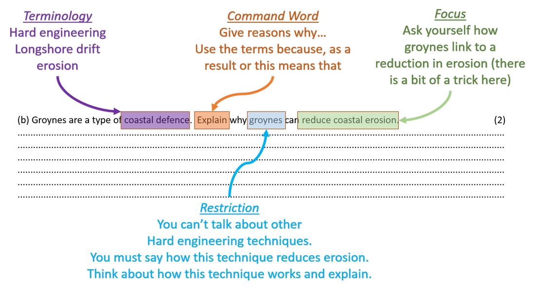
Main task 1:
READ through all of the questions first, ensuring you are using the CRaFT technique to annotate on each question before you attempt a response. See an example of CRaFT below: |
Plenary:
COMPLETE the assessment and send to your teacher once finished. When your teacher provides you with feedback, ACTION the task provided from the feedback sheet. | ||